

How does it work?
Connect the AYB unit
Buy our AYB unit (including R/C control, GPS & tablet) with Cloud Link subscription. Add a SIM card to enable Internet communication and connect the cables to the motor(s).
Our experience in automating unmanned survey vessels resulted in a game-changing product:
The Automate-Your-Boat Box
This marine automation box makes existing vessels autonomous and intelligent.
What’s typically included in a AYB kit?

A standard kit includes the following:
- AYB motor control
- 3G/4G communication with dual SIM
- Compass
- Waterproof box
- Graupner R/C controller
- Samsung Galaxy Tab Tablet
- Cloud Link:
- Mission preparation
- Mission execution
- Real-time visualization on multiple Android devices
- Online data storage
- Use of latest machine learning algorithms to improve vessel control
- Free app upgrades
Options:
- GPS
- Batteries
- Connector types (wet-mate or dry-mate)
Specification
Internet: 3G+/4G (2 SIM readers)
Wi-Fi: Access Point and Client (2.4 & 5.5GHz)
LAN: up to 4 Ethernet Ports
Serial: RS-232 and RS-485
Bluetooth: v4
Power consumption: < 20 W (excl motors)
Voltage: 12-24 V
Protection: Galvanic shielded zones / Over voltage protection
Compass: NASA Marine NMEA Compass Sensor
Accuracy: +/- 2 degrees
Gimbal: +/- 30 degrees max
Output frequency: 1Hz
Output data: NMEA 0183 sentence HDG
R/C controller: Graupner mz-10 HoTT – 2,4 GHz – 5 Channels
Receiver: Graupner HoTT GR-12 – 2,4 GHz – 6 Channels
Case IP rating: IP67
Size: 550x350x280mm
Tablet type: Samsung Galaxy Tab S2
OS: Android 6
CPU: 1.8GHz, 1.4GHz Octa-Core
Display: 8.0″ 2048×1536 QXGA Super AMOLED
Features: GPS/GLONASS, Anti-shock, IP67
Memory: 3GB RAM / 32GB ROM / MicroSD up to 128GB
Wi-Fi: 802.11 a/b/g/n/ac 2.4G+5GHz, VHT80 MIMO
Bluetooth: Version 4.1
Mobile data: 2G/3G/4G (NanoSIM)
Play Store app: ![]()
Tablet screenshots
Download the AYB datasheet
Example applications
References
MARSUR
GEODRONE 1800
ECHODRONE

CALYPSO

CATAMARAN
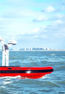
The Marsur created by dotOcean and RMA is an autonomous maritime vessel designed to enable operations with multiple heterogeneous unmanned maritime assets. Its capabilities include autonomous navigation, remote control, and coordination with other unmanned vehicles. The Marsur is equipped with advanced sensors, communication systems, and onboard processing capabilities, allowing it to operate effectively in various maritime environments.
This collaboration enables coordinated missions, including surveillance, reconnaissance, search and rescue, environmental monitoring, and maritime security operations. By working together seamlessly, these unmanned assets can cover larger areas more efficiently and effectively than traditional manned operations.


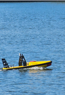
The GeoDrone 1800 is an autonomous surface vessel equipped with advanced sensors and deep learning capabilities. It can navigate shallow waters, collect data from both the seafloor and water column.
Its stable platform ensures high-quality data collection for various applications such as marine research, environmental monitoring, and hydro-graphic surveying. Overall, it autonomously conducts surveys, enhancing safety, affordability and data quality in marine operations.

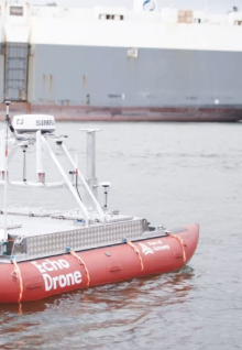
The USV Echodrone is an innovative unmanned surface vessel designed for survey operations in shallow waters. Its primary function is to conduct regular depth measurements in areas that are typically challenging for manned vessels to access. Equipped with advanced sensors and navigation systems, the Echodrone autonomously navigates and collects precise depth data, providing valuable information for port management and maintenance.
One of the key benefits of the Echodrone is its ability to optimize resources and reduce emissions compared to traditional manned survey methods. By employing electric propulsion and autonomous navigation technology, it offers a cost-effective and environmentally friendly solution for surveying shallow water environments. Additionally, its low draft allows it to access areas that are inaccessible to larger vessels, expanding the scope of survey operations.

A marine contractor build their own vessel according to their requirements. dotOcean helped choosing motors and GPS.
By adding the AYB unit, this marine contractor is now able to execute his own surveys and get real-time depth maps on his tablet. This greatly reduced their operational costs per construction site.